


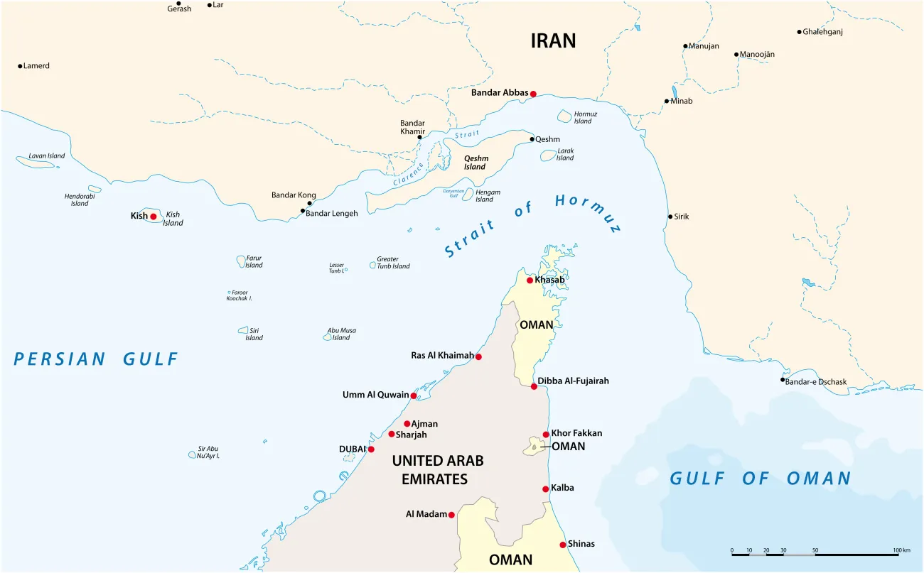
Renewed tensions affecting shipping through the Strait of Hormuz have once again drawn attention to the vulnerability of global trade to disruption at critical maritime chokepoints. The Strait of Hormuz is one of the world’s most strategically important shipping corridors, handling a fifth of global oil and liquefied natural gas flows.
The conflict in the Middle East has drawn attention to how disruption at maritime chokepoints can rapidly cascade through energy markets, supply chains, and national economies.
Indeed, roughly 20% of the world’s seaborne crude oil passes through the Strait of Hormuz. While in 2025, an average of 95 vessels transited the Strait of Hormuz every day, including 55 tankers, since the onset of the conflict, that number has fallen to less than 10 ships, as maritime insurers cancelled war risk premia. The tensions around the Strait of Hormuz highlight how disruptions of critical trade corridors can amplify supply-chain and business interruption risks.
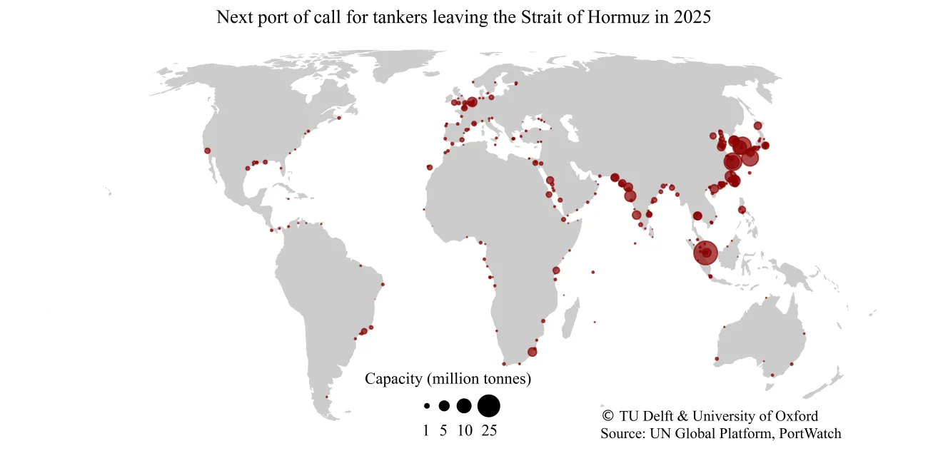
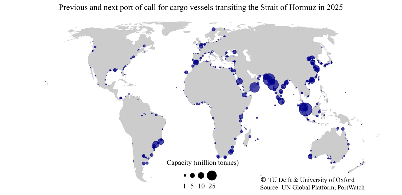
Researchers at the Environmental Change Institute (ECI) have been studying these systemic risks through the Oxford Programme for Sustainable Infrastructure Systems (OPSIS), including work underpinning the PortWatch platform and modelling of marine chokepoints in global supply chains.
PortWatch — a joint initiative of the International Monetary Fund, the University of Oxford, and Delft University of Technology — provides near real-time data on global port activity, cargo flows, and vessel movements. The platform enables analysts to track trends at major ports and key chokepoints worldwide, offering insight into how disruptions unfold and how trade patterns adjust in response. The underlying datasets are openly available via the Humanitarian Data Exchange (HDX), hosted by the United Nations Office for the Coordination of Humanitarian Affairs.
Professor Jim Hall, Professor of Climate and Environmental Risk and Lead of OPSIS at ECI, said:
Maritime chokepoints concentrate risk. When disruption occurs at these locations, the impacts are rarely confined to one region — they ripple through supply chains, affecting energy systems, food security, manufacturing and insurance markets. Timely, transparent data are essential for understanding the scale and duration of those effects.”
Alongside monitoring real-time shipping trends, OPSIS researchers are working to model the knock-on effects of chokepoint disruption across multiple sectors. In partnership with Gallagher Re and the Gallagher Research Centre, ECI researchers are developing analytical tools to help the (re)insurance industry better understand how geopolitical shocks, climate extremes, and systemic risks can amplify losses across marine, property, and contingent business interruption lines.
With around 80% of global trade transported by sea, disruptions at critical nodes can trigger vessel re-routing, longer shipping times, fuel price volatility, cargo spoilage, and congestion at alternative ports — compounding risks across interconnected infrastructure systems. Multiple hazards can threaten maritime chokepoints simultaneously. For example, the Suez Canal faces an estimated US$88 billion in trade at risk each year, while the Bab el-Mandeb Strait sees around US$117 billion in trade potentially disrupted annually.
ECI data from the study on maritime chokepoints has also been used in a new interactive visualisation hosted by Interactive Things, allowing users to explore trade at risk across key shipping corridors worldwide.
As global trade systems face overlapping geopolitical tensions, climate extremes, and economic volatility, understanding where risks concentrate — and how they propagate — is central to building more resilient infrastructure and financial systems.